Showing posts with label geology. Show all posts

Monday, November 19, 2018

Boulder

Niantic, CT  2018

I think this might be considered an erratic, a large rock deposited by a glacier.  Connecticut was covered by a glacier as recently as 15,000 years ago and boulders like this are plentiful in this area.

I will be taking a short break from blogging as I continue my recovery from recent surgeries.  I'm doing well, but have lacked the stamina to to take photo walks.  I've gone through my recent archives and have published what I consider to be some of the more interesting images.  As I regain my strength, I hope to get out more frequently.  Until then, my posts here will be rather sporadic.  

Wednesday, November 14, 2018

Toad Rock

Niantic, CT  2018

When walking the trail running through our condo community here, once can find this local landmark.  I guess it sort of looks like a toad.  At one time there was a school nearby going by the name of Toad Rock School.

Monday, November 20, 2017

Rock Pile

Niantic, CT  2017

I think this is what is left after the last glaciers melted from Connecticut, over 15,000 years ago.  

Friday, October 30, 2015

Red Rocks

South Burlington, VT  2015

Here's another interesting geologic formation seen along the shores of Lake Champlain.  The red color of these rocks comes from the high iron oxide content.  The sediments forming these rocks were laid down 500 million years ago when Vermont was close to the equator and under a tropical sea.  Over time the sediments became cemented into sandstone.  The heat and pressure which resulted from tectonic forces about 450 million years ago changed the sandstone into quartzite seen today.  This is part of the Monkton Quartzite formation.  This rock was quarried and can be found in some of the redstone buildings in Burlington and on the campus of the University of Vermont. 

Thursday, October 29, 2015

Lone Rock Point - The Champlain Thrust

Lake Champlain, 2015

Lake Champlain was formed when the last glaciers receded about 12,000 years ago.  It's hard to believe but this whole region was under 1-2 miles of ice.  Shortly after the glaciers receded, this land was below sea level due to the weight of the ice.  This allowed the Atlantic Ocean to flow into the lake via the St Lawrence River, so at one time this was a body of salt water.  The land rebounded above sea level, and over a period of time the salt water was slowly replaced with fresh water.  This photo shows a very famous geological feature known as the Champlain Thrust, a thrust fault where older rocks were forced over younger rocks .

Monday, September 21, 2015

View from the Moraine Trail

Hammonasset State Park, Madison, CT  2015

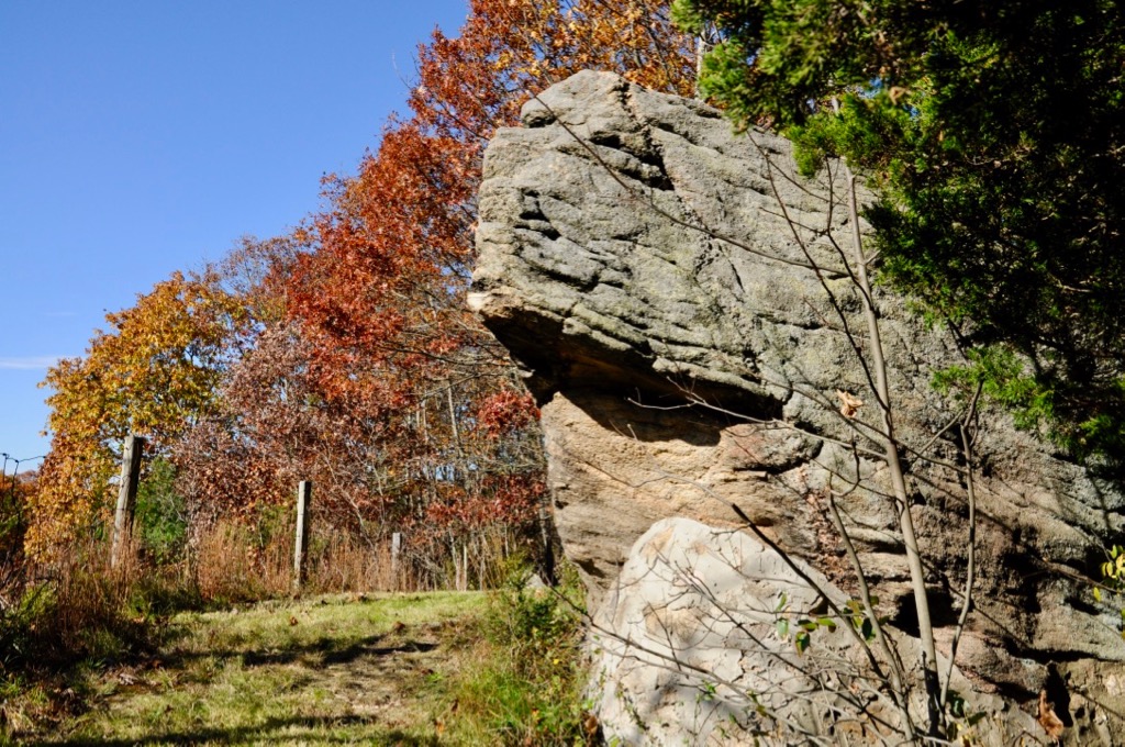
About 21,000 years ago, all of Connecticut and Long Island were covered by glacier ice which was about 1 mile thick.  The flow of the glaciers carried along rocks like these, which would pile up at the end of the glacier, where the rate of melting/evaporation, was equal to the rate of advancement of the glacier, forming what is a called moraine.  All of Long Island was formed by this process. 

Friday, May 29, 2015

Granitic Gneiss

Rocky  Neck State Park, Niantic, CT  2015

This boulder is typical of the geology found at Rocky Neck State Park.  It's granitic gneiss, a metamorphic rock which forms under intense heat and pressure.  Minerals found in this gneiss can include quartz, garnet, tourmaline and biotite.  The gneiss found here is a part of a large formation of rocks known as Potter Hill Granite Gneiss.

Sunday, November 3, 2013

Quartz

Gay City State Park, Hebron, CT

This little boulder stood out amongst the grass and fallen leaves.  It almost looked like ice and is quite different from the gray gneiss and schist that make up the majority of the rocks and boulders seen in this part of the state.

Wednesday, June 5, 2013

Old Man in Niantic

Niantic, CT

New Hampshire had it's famous Old Man of the Mountain, which unfortunately collapsed in 2003.  I'm sure this rock outcropping doesn't have nearly the notoriety of the ill-fated cliff in New Hampshire, but looking at it just right, I can see some facial characteristics.  Perhaps it doesn't look like an old man,  or even a human face at all, but it's the best Niantic can offer.

Friday, March 29, 2013

Rocky Shore

McCook Point Park, Niantic, CT

Although there are some sandy beaches along the Connecticut coastline most of the shoreline is rocky. Often times one can see exposed bedrock, eroded by the glaciers which covered the state over 14,000 years ago.  Since the shoreline here is protected to the south by Long Island, the action of the waves has done little to erode the bedrock.  In other places one can see the what the glaciers left behind, as shown above.  


Friday, October 5, 2012

Cairn

Oswegatchie Hills, Niantic, CT

The dictionary defines a cairn as a mound of rough stones built as a memorial or landmark, typically on a hilltop or skyline; or a prehistoric burial ground made of stones.  As much as I'd like to believe this cairn to be of prehistoric origins, I think it was placed here in modern times.  I have come across other cairns in this preserve.   I'm not sure who made them or why they were made.


Thursday, October 4, 2012

Rock Ridge

Oswegatchie Hills, Niantic, CT

Following along the red trail, I came upon this ridge of solid rock.  It's amazing that even without any soil to speak of at this part of the trail, somehow trees have taken a foot hold in the bedrock and can survive.

Wednesday, October 3, 2012

Rock Formations


Oswegatchie Hills, Niantic, CT

The trail passed many interesting rock formations like the ones shown here.  Readers of this blog know that I'm fascinated by rock formations, and have featured them many times in my posts.  I wonder how old these formations are and how they were formed.  I also wonder how long they have been in their present location.  

Saturday, September 8, 2012

Beach at Harkness State Park

Harkness State Park
Waterford, CT

Although this beach seen at Harkness State Park looks very inviting, for some reason, there is no swimming allowed here.  I'm not sure why.  One has to be content to just walk the beaches here, and admire the views of Long Island Sound. 

Thursday, September 6, 2012

Chapman Falls Pot Holes

Devil's Hopyard State Park
East Haddam, CT

Followers of this blog know about my interest in geology and the various rock formations found throughout Connecticut.  I had read about the pot holes found around Chapman Falls and wanted to see them for myself.  There are some fine examples of pretty deep, cylindrical holes formed over thousands of years by natural processes, although legend would have us believe these pot holes are the work of the devil himself.  According to the legend, the devil got angry after his tail got wet in the river here, and he stormed away very angry, with his hooves leaving these "foot prints"in the rocks.  Today these pot holes are like natural little pools, where people can refresh themselves in the cool water.

Tuesday, June 5, 2012

Pot Holes


Rocky Neck State Park

These pot holes are formed naturally when a rock gets caught in a depression and gets moved about within by wave action, eventually wearing down the rock.  During the process, the original rock eventually wears away and a larger rock will get trapped, and the process is repeated for I would imagine thousands of years, leaving these pot holes.  As you can see they still trap rocks, and water.  I guess the process continues to this day.